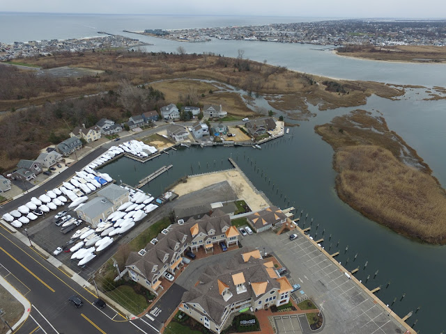
Brielle Road Aerial Panorama
While the first example above isn't perfect, I have been looking into ways to capture "Aerial Photospheres" or Spherical Panoramas and think I now have a solid workflow and toolchain down.
I've experimented with a lot of different software packages, and hosting platforms but I think I've settled on the following:
Capture:
DronePan - an iOS App that uses the DJI SDK to automatically capture appropriately overlapped photos once you fly your drone to a desired location and altitude. Basically, you fly to an interesting location and then flip the drone into "F" mode and launch DronePan. DronePan will then automatically rotate the drone and tilt the gimbal to collect 20 overlapping images in 360 degrees horizontal and 90 degrees vertical. (You do get a little above the horizon, but you can't point the camera above the drone, so, all of these have the limitation that they won't have a complete sky in them.)The main reason the image above is so messed up is, I was trying out a different SD memory card on my drone and it turns out it was too slow (write speed) for the capture rate DronePan was expecting, and I kept getting errors. Also, the weather has been terrible, overcast is not great for these types of shots, and it has been extremely windy which makes staying in the same point for the panorama very difficult.
Stitching:
PTGui - a cross platform desktop app that takes your 20 images, automatically reads the focal length and location information from the EXIF data in the images, and analyzes the photos for control points that are similar between images automatically and then generates the 360 degree equirectangular image. You can check out the full resolution (20mb) JPEG here. PTGui isn't free, but there is a free trial available.
Hosting:
This actually was the hardest part - With Google Views being deprecated I wanted to find a way to host an immersive, interactive viewer for these images that I can embed here and possibly in a dedicated gallery. There aren't that many options out there that provide a plugin-less viewer, allow embedding in an external site at a free tier without ads, and don't degrade the quality of the panorama.
I tried 360Cities, and Dermandr but was not happy with the results with either. Also, since these types of Panoramas are fairly niche, and we saw what happened with Views, I'm concerned that a third party hosting solution could go away on me at any time.
So, I'm taking on the hosting myself on Google Cloud Storage and using the open source Pannellum viewer. This uses HTML5, not plugins for the viewer.
While you can point Pannellum directly to the full size image, at 20mb, that is a lot of data for someone to have to download upfront just to see the image. Thankfully, the developer includes a pyramid generation utility that breaks the image up into smaller 512x512 tiles which are only a couple of KB each. Just like Google Maps, you just load in a few of these to start, and then the viewer pulls in the tiles required as the user zooms in and pans around.
The setup for all of this was a bit of a kluge vs just uploading an image to a 3rd party service, so I intend to write up a How-To that goes into details of the entire process from start to finish as soon as I get some nice weather to fly again and collect better images.


The proposition also permits further gambling—such as roulette—at tribal casinos. Finally, it adds a brand new} way to enforce sure state gambling legal guidelines. Most individuals can enjoy the entertainment of gambling on a balanced level, however some gamers struggle with gambling 카지노 사이트 addiction.
ReplyDelete